GEOTECHNICAL ENGINEERING
CELBRIDGE
HomeLaboratoryGrain size analysis (sieve + hydrometer)

Grain Size Analysis (Sieve + Hydrometer) in Celbridge: Reliable Soil Classification

Practical geotechnics, field-tested.

LEARN MORE

Soil conditions in Celbridge vary markedly between the historic village core along the Liffey and the newer developments rising near the M4 interchange. The older town sits on well-drained limestone-derived glacial tills, while areas closer to the river floodplain contain layers of soft alluvial silts and clays that challenge foundation design. A grain size analysis that combines both sieve and hydrometer methods captures the full particle range from coarse gravel down to the finest clay fraction, which is essential when a single borehole log can show three different soil types within two metres. Without this complete curve, the Unified Soil Classification remains ambiguous and drainage predictions unreliable. The laboratory team running these tests works under ISO 17025 accreditation and processes samples typically within five working days, delivering results calibrated to IS EN ISO 17892-4:2016. For projects where bearing capacity becomes critical, we often pair the grain size distribution with SPT drilling to correlate particle size with in-situ resistance and inform foundation selection.

A complete particle size distribution curve transforms ambiguous field descriptions into a precise soil classification that governs compaction, permeability, and shear strength.
Our service areas

How we work

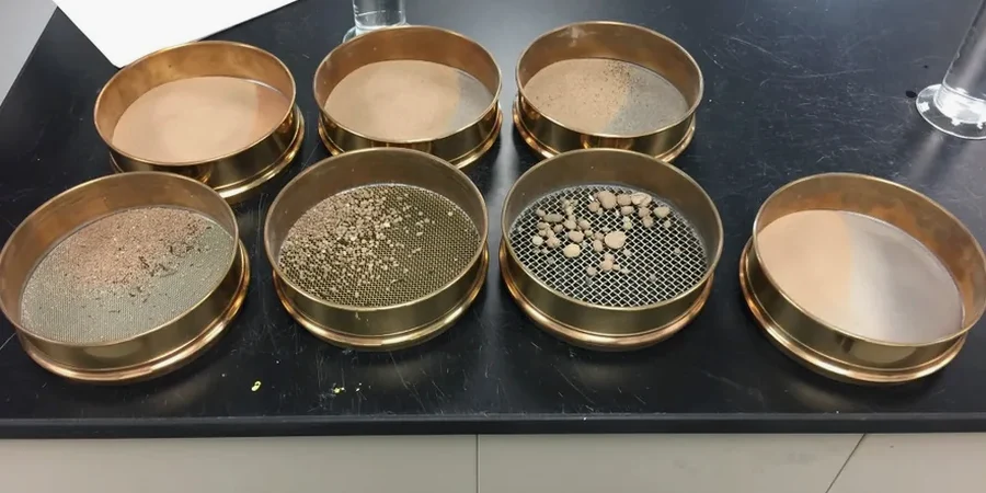
IS EN ISO 17892-4:2016 governs the combined sieve and hydrometer procedure, and its application in Celbridge is particularly relevant because of the glacial-fluvial transition soils that blanket much of the Liffey valley. The methodology starts with a thorough oven-drying and disaggregation of the sample, followed by wet sieving through a 63 μm mesh to separate the sand-gravel fraction from the silt-clay suspension. The retained material passes through a stack of sieves ranging from 75 mm down to 63 μm, while the fines undergo sedimentation analysis using a hydrometer calibrated at 20 °C with dispersant correction. Technicians record readings at 0.5, 1, 2, 4, 8, 15, 30, 60, 120, 240, and 1440 minutes, calculating particle diameters via Stokes' law with temperature-adjusted viscosity. The resulting curve yields D10, D30, D50, and D60 values directly, from which the uniformity coefficient Cu and curvature coefficient Cc are computed. These coefficients determine whether a granular soil is well-graded or poorly-graded, a distinction with significant consequences for compaction specifications and Proctor test target densities.
Grain Size Analysis (Sieve + Hydrometer) in Celbridge: Reliable Soil Classification
Technical reference — Celbridge

Site-specific factors

Celbridge sits at approximately 55 metres above sea level along the Liffey, with a population that has grown past 21,000, driving continuous residential and infrastructure expansion onto soils whose grain size distribution directly controls drainage and frost susceptibility. Sites on the south side of the river, particularly around the Castletown Estate periphery, frequently encounter laminated silts with clay partings where the percentage passing 63 μm exceeds 60%. These gradations indicate high frost heave potential per the Transport Infrastructure Ireland specification and low hydraulic conductivity below 1×10⁻⁷ m/s, meaning surface water ponds after heavy rainfall unless subsoil drainage is designed with the actual particle size data. Misclassifying a silty sand as a well-drained clean sand because only sieve analysis was performed—without hydrometer extension—leads to undersized soakaways, waterlogged foundations, and long-term sulfate attack on concrete. The combined analysis eliminates this blind spot by quantifying the fines fraction precisely, protecting against assumptions that become expensive when the November rains arrive.

Need a geotechnical assessment?

Reply within 24h.

Email: contact@geotechnical-engineering.co

Regulatory framework

IS EN ISO 17892-4:2016 — Determination of particle size distribution, IS EN ISO 14688-2:2018 — Identification and classification of soil (principles for classification), BS 1377-2:1990 — Classification tests (referenced for hydrometer procedure details where EN does not specify), Transport Infrastructure Ireland (TII) Specification for Road Works, Series 600 — Earthworks (grading limits)

Reference parameters

ParameterTypical value
Test StandardIS EN ISO 17892-4:2016
Sieve Range (Coarse)75 mm down to 63 μm
Hydrometer Range (Fines)<63 μm down to approximately 0.2 μm
Hydrometer TypeASTM 152H, calibrated at 20°C
DispersantSodium hexametaphosphate solution (40 g/L)
Key Output ParametersD10, D30, D50, D60, Cu, Cc, % gravel, % sand, % silt, % clay
Sample Mass Required500 g for fine soils; up to 5 kg for gravelly soils
ReportingSemi-logarithmic grain size distribution curve plus USCS classification

Frequently asked questions

What is the typical turnaround time for a combined sieve and hydrometer analysis from a Celbridge site?

Standard reporting is five working days from sample receipt. The hydrometer phase alone requires a minimum 24-hour sedimentation period, and oven-drying plus full sieve stack processing adds additional time. For urgent projects an express service delivering results in three working days can be arranged.

How much does grain size analysis cost for a single sample in Celbridge?

The combined sieve plus hydrometer analysis on one sample typically ranges from €80 to €180, depending on whether the soil is predominantly granular or contains a high fines fraction requiring extended hydrometer readings. Bulk pricing applies for projects submitting five or more samples.

Why is the hydrometer analysis necessary if sieve data already gives sand and gravel percentages?

Sieve analysis stops at 63 μm, so everything finer is reported as a single percentage without distinguishing silt from clay. This distinction is critical: a soil with 30% fines could be a low-plasticity silt (ML) or a fat clay (CH) with completely different strength, compressibility, and drainage behavior. The hydrometer quantifies the clay fraction specifically, enabling correct USCS classification and preventing design errors in Celbridge's mixed glacial-alluvial soils.

Location and service area

We serve projects across Celbridge and surrounding areas.

View larger map