GEOTECHNICAL ENGINEERING
CELBRIDGE
HomeInvestigationExploratory test pit

Exploratory Test Pits in Celbridge: Ground Truth Before You Build

Practical geotechnics, field-tested.

LEARN MORE

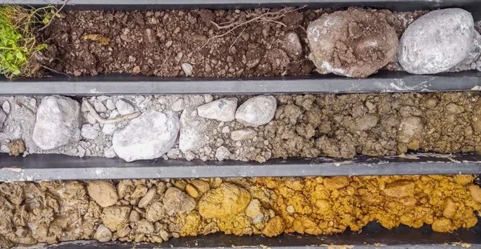
The most expensive mistake a builder makes in Celbridge isn't a design flaw—it's starting earthworks without seeing what's underground. The Liffey tributaries that cut through the town left behind alluvial pockets and varying depths of glacial till. Guessing the bearing stratum leads to over-excavation or, worse, settlement cracks six months after handover. We run exploratory test pits across Celbridge's residential and commercial sites to expose the soil profile directly. The walls of the pit tell you more in ten minutes than a desktop study ever will. From the Rye River valley to the higher ground near Castletown, our crew mobilizes a tracked excavator and a geotechnical engineer to log, photograph, and sample each horizon. Before you pour a strip footing or specify a ground improvement method, you need to know what you're really building on. Many of our Celbridge clients combine the test pit data with targeted triaxial testing when the recovered samples show soft silty clays that need strength parameters for foundation design.

A one-hour test pit in Celbridge reveals more about your foundation conditions than a week of desk research.
Our service areas

How we work

Celbridge sits at roughly 55 metres above sea level on the northern bank of the Liffey, but ground conditions shift sharply over short distances. Some plots hit dense limestone till at 1.2 metres; others, 200 metres away, find 3 metres of soft alluvium before refusal. That variability is why we log every test pit to IS EN 1997-2 standards, recording moisture, consistency, colour, and any signs of groundwater seepage. Depth typically reaches 3.5 to 4.0 metres with a 1.2-metre-wide bucket, giving enough room for the engineer to climb in and take undisturbed block samples. We document the pit face with scaled photographs and GPS-tagged locations. Each sample bag gets a chain-of-custody label straight to the lab. The resulting report includes a full soil profile, preliminary bearing capacity estimates, and clear advice on whether the ground needs improvement. Clients appreciate that we don't bury them in generic descriptions—every log ties directly to the grid coordinates on their site plan.
Exploratory Test Pits in Celbridge: Ground Truth Before You Build
Technical reference — Celbridge

Site-specific factors

Celbridge sits on the eastern edge of the Irish Midlands limestone plain, overlain by glacial tills and post-glacial river deposits. The Rye Water and its tributaries have deposited lenses of soft organic silt and peat in the lower-lying parts of town, particularly near the Meadowbrook and St. Wolstan's areas. A test pit that hits this material at 1.5 metres changes the entire foundation strategy. Skip the pit, and you might excavate to a depth that looks competent, only to have the organic layer compress under load over the next two winters. The water table in Celbridge fluctuates seasonally, and we've logged groundwater at less than 2 metres depth in several locations along the Rye Water corridor. That means trench stability becomes a safety concern during excavation. Our crew follows strict shoring protocols and never enters an unsupported pit deeper than 1.2 metres. If groundwater is high, we recommend follow-up in-situ permeability testing to quantify drainage needs before footing construction begins.

Need a geotechnical assessment?

Reply within 24h.

Email: contact@geotechnical-engineering.co

Regulatory framework

IS EN 1997-2:2007 (Eurocode 7 – Ground investigation and testing), BS 5930:2015+A1:2020 (Code of practice for ground investigations), IS EN ISO 14688-1:2018 (Identification and classification of soil)

Reference parameters

ParameterTypical value
Typical pit depth3.5 – 4.0 m (refusal at competent stratum)
Bucket width1.2 m (safe access for downhole logging)
Sampling methodDisturbed bag samples + undisturbed block samples
In-situ testsHand vane shear, pocket penetrometer per layer
Documentation standardIS EN 1997-2, BS 5930:2015+A1:2020
Groundwater noteSeepage depth and rate logged if encountered
Report delivery5–7 working days with lab results

Frequently asked questions

How much does an exploratory test pit cost in Celbridge?

For a single test pit in Celbridge with full logging, sampling, and a summary report, expect between €500 and €870 excluding VAT. The final figure depends on access, depth, and the number of samples sent to the lab.

How deep can you excavate a test pit in Celbridge?

We typically reach 3.5 to 4.0 metres with a standard tracked excavator. Depth is limited by machine reach and trench stability. If the target stratum is deeper, we'll recommend switching to CPT or SPT drilling.

Do you need a test pit before building a house extension in Celbridge?

Yes, and most structural engineers in Kildare will require it. An extension adds load to existing foundations, and the soil under the new footprint may differ from the original house. A single pit gives the engineer the bearing stratum depth and soil type needed to design the footing correctly.

What happens if you hit groundwater during excavation?

We log the depth and rate of seepage immediately. If water enters the pit faster than it can be pumped with a small sump, we note it in the report and usually recommend a permeability test to size any required dewatering system.

Location and service area

We serve projects across Celbridge and surrounding areas.

View larger map